The American West is defined by its vastness, and nowhere is this more apparent than in Utah. From the red rock cathedrals of the south to the jagged, snowy peaks of the Wasatch Range in the north, the landscape is as intimidating as it is beautiful. For travelers, this rugged terrain presents a unique challenge. The distances are long, the cell service is often nonexistent, and the roads can quickly turn from paved highways to gravel washboards.
Getting lost here isn’t just an inconvenience; in the deep desert or high mountains, it can be a safety hazard. Whether you are planning a tour of the “Mighty 5” National Parks, hunting for hidden slot canyons, or just driving cross-country on I-70, having the right navigation resources is critical. Successful exploration requires a blend of modern technology and old-school reliability.
The Digital Toolkit: Apps for the Modern Explorer
Most journeys begin with a smartphone. While reliance on technology has its drawbacks in remote areas, digital tools offer unparalleled convenience when you have a signal or have prepared ahead of time.
Mainstream Navigation Apps
For general highway driving, Google Maps and Apple Maps remain the gold standard. They provide real-time traffic updates, which is vital if you are driving through the Salt Lake City corridor or trying to avoid construction delays near Moab. However, these apps often struggle to differentiate between a paved county road and a rugged jeep trail once you leave the main highways. Always double-check your route settings to avoid unpaved roads unless your vehicle is equipped for them.
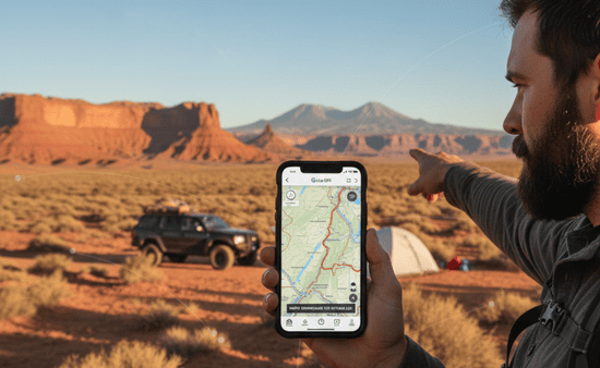
specialized Outdoor Apps
If your itinerary involves hiking, off-roading, or camping on Bureau of Land Management (BLM) land, you need more robust software. Apps like Gaia GPS and OnX Offroad are favorites among locals. These platforms allow you to see public land boundaries, specific trail types, and topographic details that standard maps miss.
Crucial Tip: Utah’s geography—deep canyons and high remote plateaus—is notorious for blocking cell signals. You must download your maps for offline use before you leave civilization. relying on a live data connection in the San Rafael Swell or Grand Staircase-Escalante is a recipe for getting lost.
The Analog Backup: Why Paper Still Reigns Supreme
There is a saying among veteran desert rats: “Batteries die, but paper doesn’t.” In a state where extreme temperatures can sap your phone battery and GPS satellites can be fickle in narrow canyons, carrying physical navigation tools is not just nostalgic; it is essential.
The Benchmark Road & Recreation Atlas
For anyone serious about exploring the Western United States, the Benchmark Atlas series is indispensable. Their Utah edition offers a level of detail that puts most fold-out maps to shame. It clearly distinguishes between 4WD roads, gravel roads, and paved highways. It also highlights campgrounds, trailheads, and points of interest. Keeping a copy in your backseat ensures you always have a “big picture” view of where you are, which is helpful when you need to reroute on the fly.
Topographic Prints
For hikers entering the backcountry, a general Utah map isn’t enough. You need specific topographic maps, such as the National Geographic Trails Illustrated series. These are waterproof, tear-resistant, and cover specific areas like Zion National Park or the High Uintas Wilderness with incredible precision. They show elevation contours, water sources, and mileage between trail junctions, ensuring you can navigate safely on foot.
Official State Resources: UDOT and Beyond
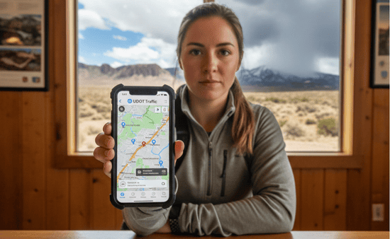
The state government provides excellent resources that are often overlooked by tourists. The Utah Department of Transportation (UDOT) operates a robust traffic website and app. This resource is particularly valuable during the winter months or monsoon season.
Utah weather is volatile. A sunny day in St. George can happen simultaneously with a blizzard in Parleys Canyon. The UDOT Traffic app gives you access to hundreds of live traffic cameras, road weather sensors, and plow locations. Checking this before you drive over high mountain passes can save you from getting stuck in a dangerous storm.
Additionally, the Utah Office of Tourism and local visitor centers in towns like Kanab, Moab, and Vernal provide free, updated maps and brochures. The staff at these centers are often the best source of real-time information regarding road washouts or closures that haven’t made it to the digital map providers yet.
Navigating the Scenic Byways
Sometimes, the drive is the destination. Utah boasts 28 Scenic Byways, including the famous All-American Road: Scenic Byway 12. Navigating these routes is usually straightforward, as they are well-signed, but having a guide can enhance the experience.
Many of these byways have dedicated websites or audio guides that you can download. These resources narrate the history, geology, and ecology of the landscape as you drive through it, turning a simple commute into an educational tour.
Adventure Smart: A Final Word on Preparation

Accessing the remote corners of the Beehive State is a privilege that comes with responsibility. Navigation is more than just knowing which turn to take; it is about understanding the environment.
Always tell someone your plan. If you are venturing solo into remote areas, consider carrying a satellite messenger device like a Garmin inReach. These devices allow you to send texts and GPS coordinates via satellite, bypassing the need for cell towers entirely.
When you combine high-tech GPS tools with reliable paper backups and real-time local intelligence, you unlock the full potential of the state. You can move with confidence from the salt flats to the sandstone arches, knowing that no matter how far off the grid you go, you can always find your way back.
Hit the Road with Confidence
Utah is a playground for the adventurous spirit, but it demands respect. By equipping yourself with the right mix of apps, physical maps, and local knowledge, you ensure that your memories are defined by the stunning vistas you found, not the hours you spent lost on a dirt road. Pack your gear, download your maps, and get ready to discover what lies around the next bend in the canyon.